

Thomas and Addis on top of the Stone Bamboo Shoot
Despite the best efforts of the local government to tame two of them, the wonderful Pingxi Three Peaks (平溪三尖) still offer plenty of scope for hikers looking a slightly more challenging walk. Fengtou Point (the only peak of the three not yet interfered with by the authorities) remains the best goal for a challenge hike, and the walk along the whole ridge is presently perhaps my favorite walk in the Taipei area. Unfortunately the Stone Bamboo Shoot and Shulung Point have both suffered from that baffling, rabid desire among locals-in-power to tame the beautiful, wild countryside hereabouts with ugly, wide stone stepped paths, and there’s no doubt that neither summit is quite as rewarding a climb as they were a decade ago. However, the very steepness of the two peaks means that there’s more than one way to climb each of them, and plenty of fun to be had if you choose the right route.

The magnificent north ridge of Shulung Point

The trail beyond the summit of Shulung Point is rough and adventurous
For fitter hikers with the best part of a day and some good weather, undoubtedly the best way to scale the two peaks is via a fairly strenuous but magnificent loop hike starting at the tiny settlement of Yikeng (一坑) and ending (eventually) at nearby Jingtong (菁桐), the terminus of the Pingxi Branch Railway Line. It’s very much longer and much tougher than the short circuit of the two peaks described in Taipei Escapes 1 (page 149), but it’s a magnificent hike of great beauty, and makes for a very rewarding day.

.

The view from the summit of Shulung Point
The hike begins where the Taipei Escapes hike finishes – at tiny Yikeng village, a kilometer or two uphill from Jingtong. Shulung Point is a conspicuous, tree covered pyramid rising above the village, and after a short walk through the single lane hamlet, the trailhead is clearly marked on the right by a map board. Despite the colorful map, it’s a natural, narrow dirt trail all the way up, and it takes little time before settling into the steep and rough climb. It gets even steeper towards the top, and then suddenly emerges on the tiny summit (622 meters) of Shulung Point, which offers a magnificent, near-360-degree view in clear weather.
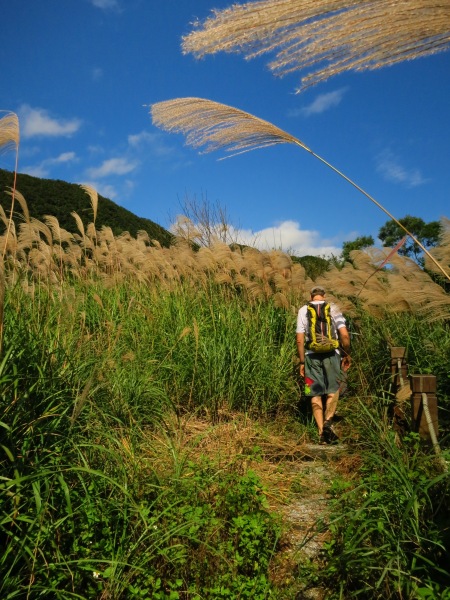
On the trail near the Pingxi-Xizhi mountain road
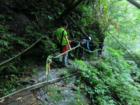
The stone stepped path up from Jingtong, so out-of-place in such a beautiful spot, descends on the right, but ignoring this, and take the third route leaving the summit: another narrow, overgrown dirt trail ahead, which drops steeply off the peak, and then follows its magnificent north ridge. The next 90 minutes or so is by far the hardest part of the hike, keeping as close as possible to the extremely narrow blade of the ridge. The first part is especially impressive, lying right beside a sheer, vertical, and completely unguarded cliff, dropping way, way down into jungle far below: the views are magnificent. Later on the trail drops off the ridge several times and then climbs back onto it a little later – much of the way is roped, with some precipitously steep and pretty precarious stretches to negotiate – don’t attempt this trail in bad weather.
It’s almost a disappointment when the trail finally (and unexpectedly) emerges onto a much wider ‘tourist’ trail, beside another colorful board map. Turn right and this wide trail (which has been ‘improved by the local authorities, although thankfully without stone steps and all that crap – so far…) meanders attractively through the woods: an undemanding and scenic walk which eventually reaches the mountain road connecting Pingxi and Xizhi. The final few meters before joining the road are through a sea of silver grass with a good view of the wooded Shikongdalun (石硿大崙) ridge rising behind.

In the Mountain Demon Cave
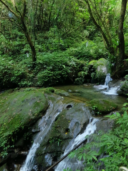
Turn right along the road, and in a minute or two a wide, signposted trail, almost a track, on the right is the Jingtong Old Trail (菁桐古道). The wide, easy trail is a bit of a shock after what’s come before, but in just five minutes or so, it narrows and splits in two. Both ways lead down to Jingtong eventually; we took the right fork, which climbs mud steps with wooden risers, then descends the far side of a small ridge, diving into an enchanting jungle-clad glen. It’s a very scenic walk and before too long, the first of two old mining tunnels called the Mountain Demon Caves is on the left, cut through the rock. After walking through the first (about 50 meters long and extremely muddy inside) a rough dirt trail on the left (just before the mouth of the second, shorter tunnel), climbs steeply to join a wider track, climbing past a motor bike (!), lying abandoned and rusting beside the trail, to reach a junction beside another board map.

The Mountain Demon Cave, one of two abandoned tunnels dug through the hills here to make way for a mineral railway carrying coal out from mines
The trail beside the map is a direct route to the Stone Bamboo Shoot, but it’s a famously tough one with some nasty rock faces to scale (a small metal sign warns that it’s dangerous and anyone taking it should take great care) – I got spooked after the first couple of awkward rock pitches; beyond them there’s a long steep drop back into the valley from there before scaling the Shoot itself, and although I’ve never dared do it, the last part of the route to the top of the finest of the Pingxi Three Peaks looks pretty death-defying, looking down it from the summit above.
A stretch of the Jingtong Old Trail lies through a beautiful wooded glen

.
.
The lower part of this, the trail to the summit of the shapely Stone Bamboo Shoot, is graced with wide stone steps – very inappropriate considering how rough the trail becomes later. Further up it’s natural, steep and beautiful as ever. The Stone Bamboo Shoot trail surely needs no introduction – it’s a popular favorite among hikers – short and quick to scale yet fun, steep, very scenic, and with a cracking view from the top. Scaling it via the fun escarpment route (beside the sheer cliffs) on the east, then dropping down the easier, gentler trail through the woods on its west face to complete the day’s walk at Jingtong makes for a perfect end to an outstanding hike. In an area where the hiker is remarkably spoilt for choice, hikers new to the area would probably be wise to enjoy one of the even more fabulous hikes nearby (The Fengtou Ridge walk, the short and simple but very exhilarating Filial Son Mountain loop, or the easy and extremely popular Sandiaoling Waterfall Walk ). After getting to know those classic day hikes though, this one is possibly the pick of a very large bunch of hiking opportunities in this amazing area.

The Stone Bamboo Shoot
